Until November 1, 1966, the current Una district was a Tehsil of the Punjab district of Hoshiarpur. Following Punjab's reorganization, all hill areas, including Una Tehsil, were transferred to Himachal Pradesh. Since then, until September 1972,it had been the Tehsil of the then Kangra district.
On September 1, 1972, the Himachal Pradesh government reorganized the then-Kangra district into three districts: Una, Hamirpur, and Kangra.
Una district is divided into five Sub-Divisions (Una, Amb, Haroli, Bangana, and Gagret), five Tehsils (Una, Amb,Bangana, Haroli, and Ghanari), and seven Sub-Tehsils (Bharwain, Ispur, Jol,Bihru Kalan, Dulehar, Gagret at Kaloh, Mehatpur Basdehra) (Una, Bangana,Gagret, Amb and Haroli).
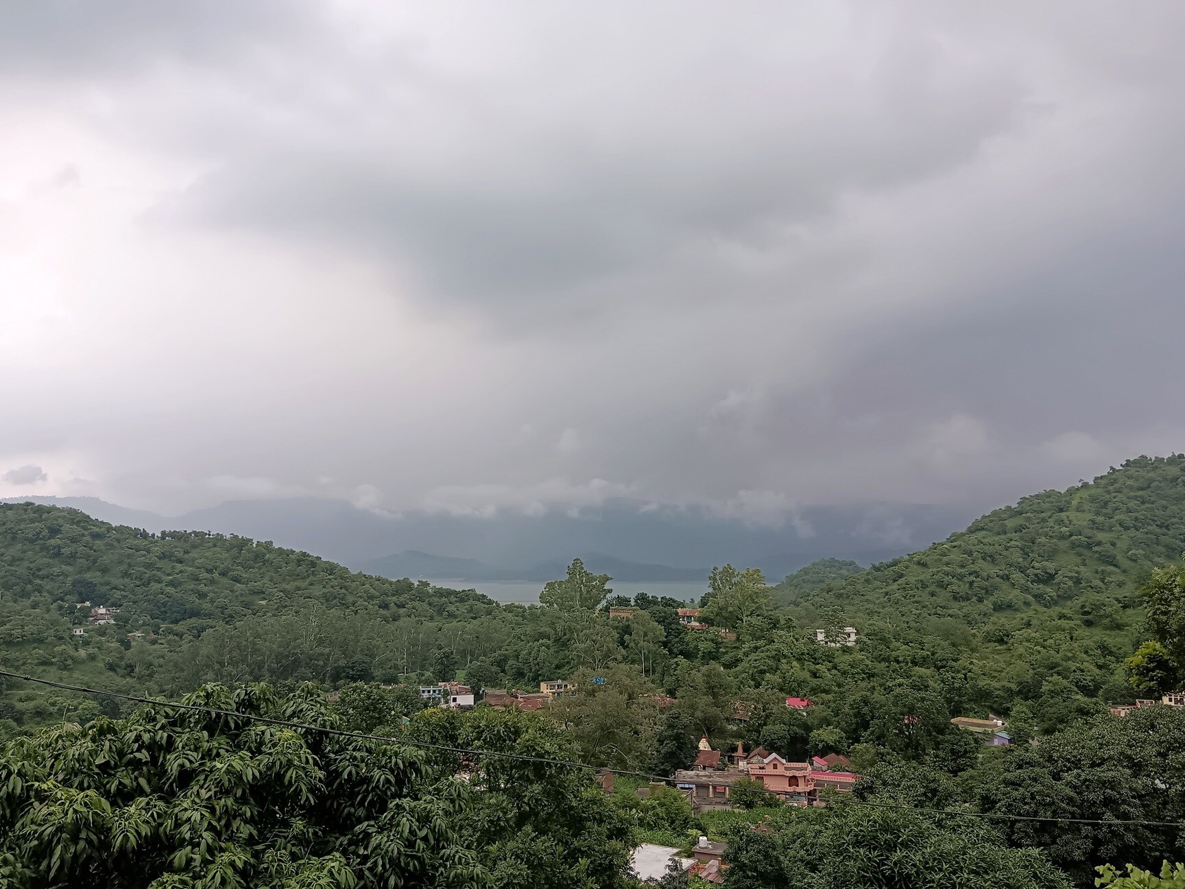
Nestled at the foothills of the majestic Himalayas, Una is a hidden gem where nature, spirituality, and authentic Himalayan culture blend effortlessly. Unlike crowded hill stations, Una offers a peaceful escape for travelers seeking tranquility, warm hospitality, and untouched landscapes.
Surrounded by rolling green hills, fertile valleys, and gentle rivers, Una welcomes visitors with pleasant weather, scenic countryside, and breathtaking sunrise and sunset views. The region is deeply rooted in spirituality, home to revered temples such as Chintpurni, Dera Baba Barbhag Singh, and Piplu, attracting seekers from around the world.
Una is the perfect base for exploring Himachal’s diverse beauty — from serene village walks and bird-watching to nearby hill destinations and cultural experiences. Visitors can enjoy authentic local cuisine, traditional festivals, and the simplicity of rural Himalayan life, offering a rare opportunity to connect with nature and people.
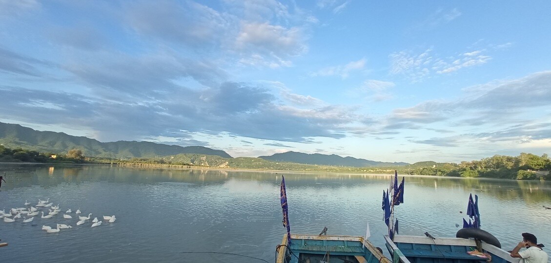
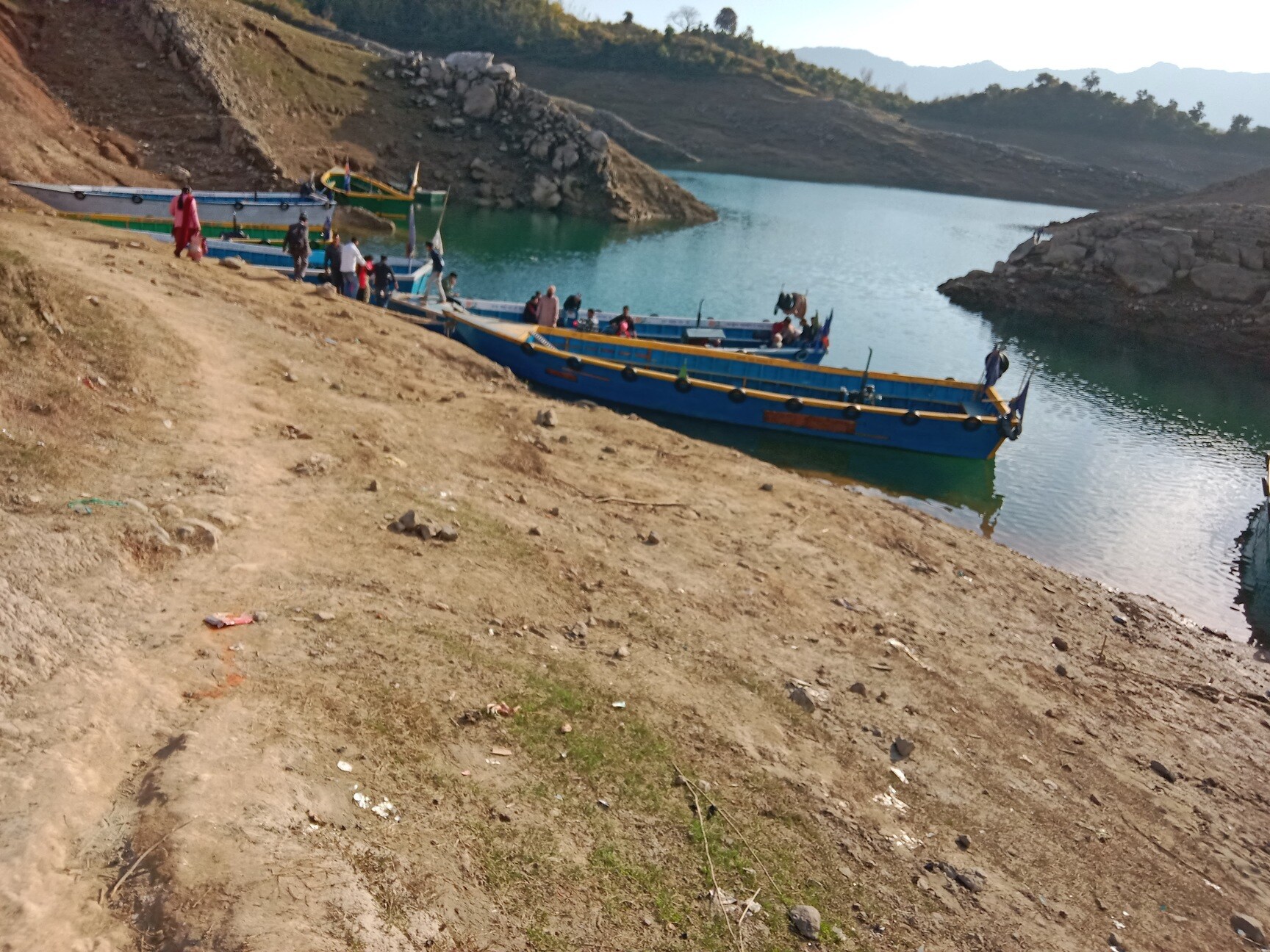
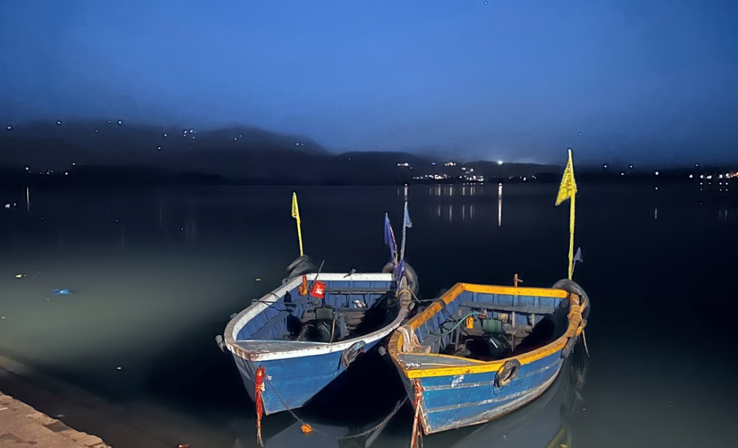
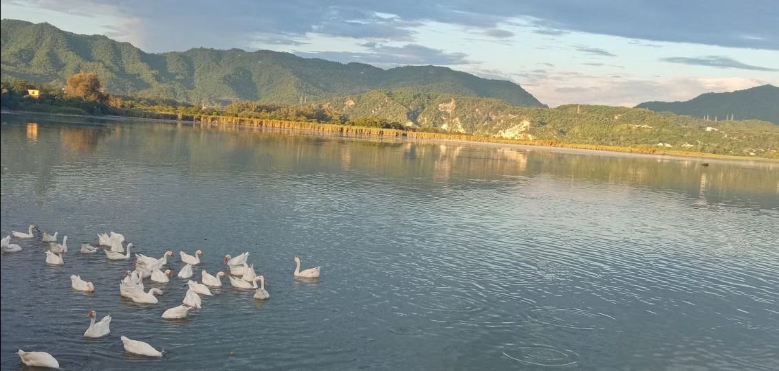
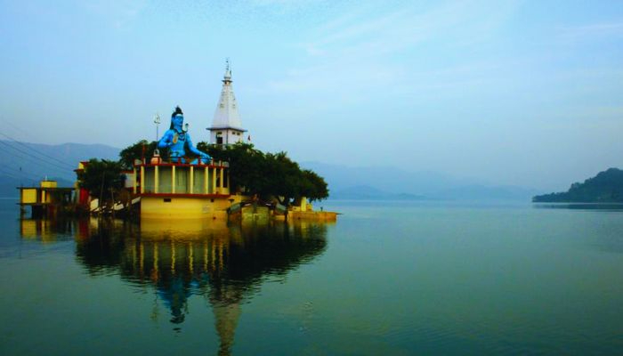
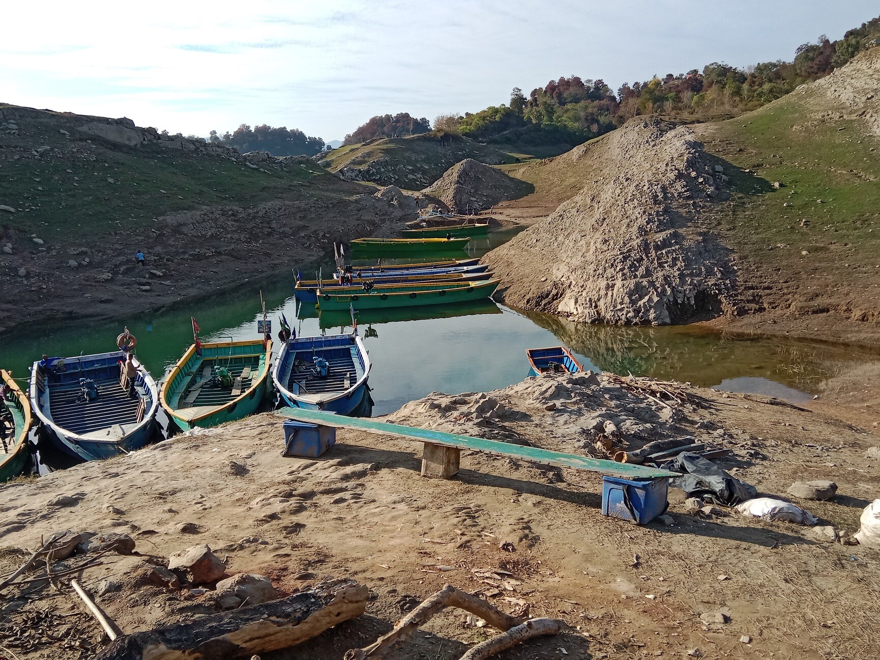
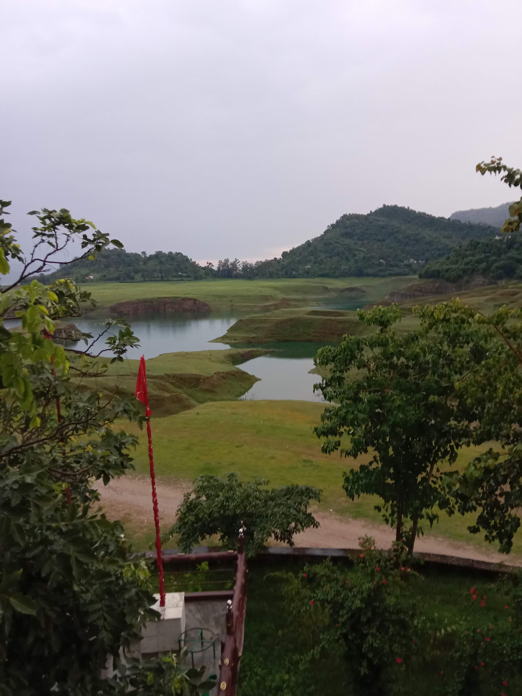
Govind Sagar Lake, formed on the mighty River Sutlej after the construction of the Bhakra Hydel Dam, stands as one of the largest and most significant reservoirs in India. The lake is named in honor of Guru Gobind Singh, the tenth Sikh Guru, adding historical and spiritual depth to its natural beauty.
If you have ever traveled to Kullu–Manali, you may recall catching a fleeting glimpse of this vast blue expanse near Bilaspur. But beyond that brief roadside view lies a world of serene landscapes and ever-changing colors.
Let us now take a closer photo journey into the lesser-explored stretches of Govind Sagar Lake in the Una region of Himachal Pradesh, where calm waters, open skies, and untouched surroundings create moments worth lingering over.
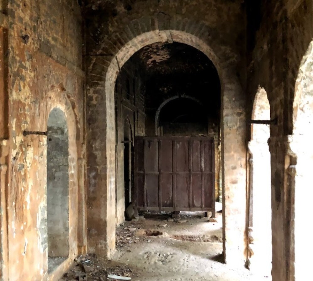
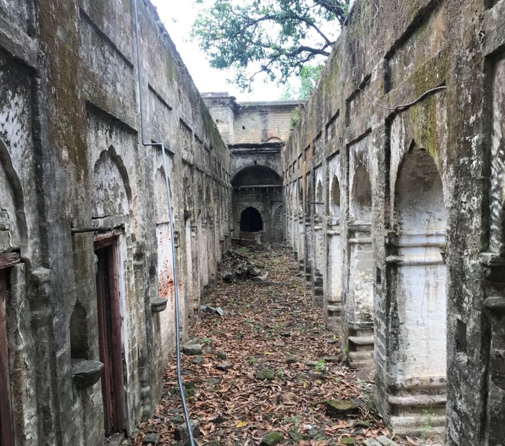
Kutlehar State, covering an area of approximately 2,200 square kilometers (850 square miles), was one of the prominent princely states of India. Founded in the 10th century, Kutlehar emerged as an independent hill kingdom and rose to prominence over the following centuries.
The kingdom reached the height of its power during the reign of Raja Jas Pal in the 11th century, when its territory is believed to have stretched across the vast lands lying between the Satluj and Beas rivers. Its strategic location made Kutlehar both influential and vulnerable, drawing the attention of powerful invaders and empires.
Over the centuries, Kutlehar witnessed numerous conflicts, including confrontations with Mohammad bin Tughlaq in 1337, Timur in 1398, and the Mughal Emperor Akbar in 1556. During Akbar’s reign, the Raja of Kutlehar was required to pay an annual tribute of 1,600 rupees, along with gifts of jewels, fine cloth, and hill pheasants presented on the Emperor’s birthday. As a symbol of loyalty, a prince of royal blood was kept in attendance at the Imperial Court in Delhi, while a contingent of 500 foot soldiers, maintained at Kutlehar’s expense, served under the Mughal Emperor.
In 1700, when Anandpur Sahib came under Mughal attack, Guru Gobind Singh Ji passed through Kutlehar territory. Defying Mughal orders, the Raja of Kutlehar refused to take up arms against the Sikh forces. This act of courage invited severe retaliation from the Mughal authorities, resulting in a drastic reduction of Kutlehar’s territory, leaving the Raja with only a fraction of his former dominion.
In 1701, the Raja and Rani of Kutlehar met Guru Gobind Singh Ji at Rewalsar, where the Guru presented the Raja with his sword as a token of gratitude and honor. Remarkably, the Kutlehar royal family still preserves this sacred sword to this day.
In later years, Kutlehar’s territory extended across parts of present-day Una district, Talhatti in Hoshiarpur, Bassi Bachertoo in Bilaspur, and regions of Hamirpur. In 1815, the state was annexed by Maharaja Ranjit Singh, and the Raja was exiled to the fort at Charatgarh. Following the British annexation of Punjab, the Raja was eventually permitted to return to the hill regions.


Tira Sujanpur, also known as Sujanpur Tira or Sujanpur Tihra, is a town and municipal council in the Hamirpur district of Himachal Pradesh. Founded in the 18th century by the Katoch dynasty, the town is located midst the Himalayan foothills on the southern bank of the Beas River. It was one of the centers of Kangra-style miniature paintings (a chitrakala school) and Hindu temples built in an unusual blend of conventional Nagara architecture shrines with Mughal architecture palace, the latter decorated with floral murals of legends from the Ramayana and the Mahabharata.
The town was founded as "Sajjanpur" by Raja Sansar Chand Katoch in the 18th century. Over time, it was referred to as Sujanpur. The Katoch dynasty developed it as a capital, adding a fort near it along a Tihra – a strip of the foothills. This led to the current name "Tihra Sujanpur".[1] The king added several Hindu temples, a palace and square-shaped training center for warriors, locally called the "Chougan". It served the needs of its time where an alliance of Sikh and Hindu rulers were prone to plunder raids and invasion from the Mughal governors and Muslim tribes from Afghanistan and northwest Indian subcontinent. With the British rule, a period of relative peace arrived. The town and its historic buildings were damaged by the 1905 Kangra earthquake. After the end of the colonial era, the Chougan evolved into a public square hosting cultural festivals and other public events.


Shri Naina Devi Ji, the chief ‘Shakti Peeth’ among the world famous ‘Peeths’ of India, is situated in Bilaspur District in the State of Himachal Pradesh, India. It is located eighty kilometers from the Bilaspur town, one hundred eight kilometers north of Chandigarh, thirty six kilometers south from Nangal and twenty kilometers from Bhakhra Dam.
The ‘Shakti Peeth’ is sited one thousand two hundred and nineteen meters above the sea level. The nearest airport to reach this place of pilgrimage is Chandigarh airport; and the nearest railway stations are Anandpur Sahib and Nangal in Panjab.


Shree Rukmani Kund is a water reservoir surrounded by mountains in the middle of the Sivalik Hills Forest in Bilaspur district, Himachal Pradesh, India. Rukmani Kund, 28 km from Bilaspur, was selected in HGKK (Har Gaon Ki Kahani Programme) for the year 2012–2013.Rukmani Kund is considered the place of sacrifice of Rukmani and a Mela (fair) has been started here since some years on the name of sacrificer. A small temple has also been constructed here. It is the source of water supply for so many villages in the area.
The entire Auhar region was in trouble because of dearth of water despite their repeated efforts to dig a well. Once the ruler of Barsandh had a dream that in case his son or daughter in law is offered as a sacrifice, water could come out. Legend is there that a newly married young lady named Rukmani of Taredh Village married to Rundh Family, Rajput ruler of Barsandh village, was buried alive by the side of the spot which was selected for digging a Baoli (Tank). The daughter-in-law, Rukmani offered herself in preference to her husband. She sacrificed her life and the present Rukmani Kund is a result of her courageous act. It is said that she was buried alive at the place where we have this Kund today.
According to Omacanda Hāṇḍā in Buddhist Art & Antiquities of Himachal Pradesh, Up to 8th Century A.D.,[4] such stories of Woman sacrifices were common instances in which women were sacrificed to Nāga Devta for the sake of water. Similar stories can be taken into consideration like Rupi Rani of Gushal Village in Lahul Valley, Rani Nayana of Raja Sahil Varman of Chamba, Bichi of Sirmaur and Kandi Rani of Kishtwar in Jammu who were sacrificed to Nāga Devta for the sake of water. Human Sacrifices to Nāga Devta has been one of the most conspicuous features of Austric Tribes.
Grass (baggad) hanging from the walls of the Kund is considered her hair. And it is there because of the magical power of the reservoir water. People tie ribbons, bangles to the grass to offer tribute to Rukmani. It is also believed that the waters of this reservoir can cure skin ailments.
Rukmani belonged to Auhar (erstwhile Tared Village) and even today people from Rukmani's village don't drink or bathe in the Kund's waters. Such is the pride they take in their daughter's sacrifice.


Kufri is a resort hill station in the district of Shimla, India. It is located 12 km (7.5 mi) from the state capital Shimla on the National Highway 5 (also known as Hindustan-Tibet road). On the Kufri Avenue, the main thoroughfare, boutiques and restaurants mix with Indian-style hotels and souvenir shops are to look for during a visit.
The name Kufri is derived from the word kufr meaning "lake" in the local language. The highest point in the surrounding region, Kufri has a Himalayan wildlife zoo which hosts rare antelopes, felines and birds including the Himalayan monal, the state bird of Himachal Pradesh until 2007. During winter a meandering path through the potato plantations turns into a popular ski track.
Kufri is located at 31.10°N 77.25°E. It has an average elevation of 2,720 metres (8923 feet).
The region around Shimla including Kufri was once a part of the Kingdom of Nepal until the area was ceded to the British Raj as part of the Sugauli Treaty. This region remained obscure from the rest of the world until the British 'discovered' it in 1819.


The British-era Bantony Estate in Shimla, a grand private castle once was the summer Palace of the erstwhile Maharaja of Sirmaur, a grandeur architectural landmark. The castle is located near Scandal point on Kali Bari Road.The Bantony Esttate is a heritage site built during the British era and is situated on the Bantony Hill of Shimla. The beautiful wooden architecture of the building amidst the sprawling lawns is a site worth exploring.
Bantony Castle is one of the historic and monumental buildings of Shimla town and has a very rich history. It was built over 145 years ago. Before the castle was built, the estate had only a cottage that belonged to Captain A. Gordan and later in 1880, the castle was built up and became the summer residence of Maharaja Sirmour. During the first World War it was handed over by Maharaja Sirmaur to the Govt. of India for housing additional temporary offices for army.
After independence, ‘The Tribune’ office was shifted here from Lahore. Later on it remained the office of the Director General of Police. The main building is a two-storeystructure constructed in the mockTudor style, part chalet and crowned with a sloping roof with mini-towers. The castle is said to have been designed by TEG Cooper. In the year 2017, the Himachal Pradesh Government acquired the Bantony Castle Estate from the owner and restored the heritage building to establish a digital Museum and Light & Sound Show to portray the history, Art and Culture of the State.


The Kalka–Shimla Railway is a 2 ft 6 in (762 mm) narrow-gauge railway in North India which traverses a mostly mountainous route from Kalka to Shimla. It is known for dramatic views of the hills and surrounding villages. The railway was built under the direction of Herbert Septimus Harington between 1898 and 1903 to connect Shimla, the summer capital of India during the British Raj, with the rest of the Indian rail system.
Its early locomotives were manufactured by Sharp, Stewart and Company. Larger locomotives were introduced, which were manufactured by the Hunslet Engine Company. Diesel and diesel-hydraulic locomotives began operation in 1955 and 1970, respectively.
On 8 July 2008, UNESCO added the Kalka–Shimla Railway to the mountain railways of India World Heritage Site.
Shimla (then spelt Simla), which was settled by the British shortly after the first Anglo-Gurkha war, is located at 7,116 feet (2,169 m) in the foothills of the Himalayas. The idea of connecting Shimla by rail was first raised by a correspondent to the Delhi gazette in November 1847.
Shimla became the summer capital of British India in 1864, and was the headquarters of the Indian army. This meant that twice a year it was necessary to transfer the entire government between Calcutta and Shimla by horse and ox drawn carts.
In 1891 the 5 ft 6 in (1,676 mm) broad gauge Delhi–Kalka line opened, which made the construction of a branch line up to Shimla feasible.
The earliest survey was made in 1884, followed by another survey in 1885. Based on these two surveys, a project report was submitted in 1887 to the government of British India. Fresh surveys were made in 1892 and 1893, which led to four alternative schemes being suggested - two adhesion lines, 67.25 mi (108.23 km) and 69.75 mi (112.25 km) long, and two rack lines.Fresh surveys were again made in 1895 from Kalka to Solan to determine whether a 1 in 12 rack or a 1 in 25 adhesion line should be chosen. After much debate, an adhesion line was chosen in preference to a rack system.
Construction of the Kalka–Shimla Railway on 2 ft (610 mm) narrow-gauge tracks was begun by the privately funded Delhi-Ambala-Kalka Railway Company following the signing of a contract between the secretary of state and the company on 29 June 1898.The contract specified that the line would be built without any financial aid or guarantee from the government. The government however provided the land free of charge to the company. The estimated cost of 8,678,500 rupees doubled by the time the line was opened. The Chief Engineer of the project was Herbert Septimus Harington and the Chief Contractor was Sujan Singh Hadaliwale.
The 95.68 km (59.45 mi) line opened for traffic on 9 November 1903 and was dedicated by Viceroy Lord Curzon. This line was further extended from Shimla to Shimla Goods (which had once housed the bullock cart office) on 27 June 1909 making it 96.60 km (60.02 mi).
The Indian Army were sceptical about the two feet gauge chosen for the line and requested that a wider standard gauge be used for mountain and light strategic railways. Eventually the government agreed that the gauge was too narrow for was essentially a capital city and for military purposes. As a result, the contract with the railway company was revised on 15 November 1901 and the line gauge changed to 2 ft 6 in (762 mm) with the track built to date being regauged. Some sources however state the regauging wasn't undertaken until 1905.
In 1905 the company took delivery of a 10-ton Cowans Sheldon travelling crane to assist with lifting rolling stock back onto the tracks after accidents and for general track maintenance. Due to the high capital and maintenance costs and difficult working conditions, the railway was allowed to charge higher fares than on other lines. Nevertheless, the company had spent 16,525,000 rupees by 1904 with no sign of the line becoming profitable, which lead to it being purchased by the government on 1 January 1906 for 17,107,748 rupees. Once it came under the control of the government the line was originally managed as an independent unit from the North West Railway office in Lahore until 1926, when it was transferred to Delhi Division. Since July 1987, the line has been managed by the Ambala Division from Ambala Cantt.
In 2007, the Himachal Pradesh government declared the railway a heritage property. For about a week, beginning on 11 September 2007, a UNESCO team visited the railway to inspect it for possible selection as a World Heritage Site. On 8 July 2008, it became part of the mountain railways of India World Heritage Site with the Darjeeling Himalayan and Nilgiri Mountain Railways.
Nichar is a village located in the Kinnaur district of Himachal Pradesh state, India, at an altitude of 2100 meters. It is located on the old Hindustan-Tibet road. Most of the people follows Hinduism as well as Buddhism. It is known for natural water body called "chhalang bayu". The Usha Mata temple is in Nichar. The people of Nichar celebrate a fair called 'HU HU mela' (BAATI mela in local language). Nichar is one of the three administrative areas of Kinnaur distt. The region has a variety of flora and fauna and is home to wildlife species such as red bears, antelopes, and Ghoral. Nichar has wide range of alpine forest. That's why it is called as green valley. It is most green village in distt Kinnaur. The temperature of Nichar remains moderate throughout the year and hence, tourist can visit here in any season. With its natural environment and wildlife, it has become one of the most sought-after places to visit in Kinnaur.


Moorang(3591m): Situated above the left bank of Satluj at some distance from the confluence of the Tirang and 39 kms away from the Kalpa. The location is very beautiful and approach to this picturesque village is through apricot orchard. The dell is encircled by the lofty mountains on every side, except westward open to the Satluj, on the bank of which there is an old fort believed to be built by Pandavas. The fort has a square structure situated on a knoll overlooking the Satluj. Its main gate is approachable by a detached ladder. It has a flat roof. The local deity is Urming and there are three structures dedicated to the deity each existing in Thwaring, Garmang and Shilling. Generally these are empty as the ark of the deity remains in the fort. On a sacred day the ark is taken to the above named places. The ark has got 18 'mukh', made of silver, gold and brass. The 18 mukh represents the 18 days of the great epic Mahabharat.


A must see tourist spot for the solitude lovers and avid worshipper of nature, Lipa Asrang Sanctuary is around at a height of 4,000 to 5,022 m. The sanctuary is spread over an area of around 30.89 sq km. The variety of flora found in this sanctuary includes dry coniferous forest, dry alpine scrub, dwarf juniper scrub, dry broad leaves, western Himalayan temperate forest, and coniferous forest.
The most commonly found fauna in this sanctuary are Yak, Leopard, Ibex, Goral, Brown Bear, Blue Sheep, Himalayan black Beer, Musk Deer etc. Random tourists are not allowed to enter this sanctuary. So they need to take prior permission to explore the sanctuary


The Shri Bagalamukhi Mata Temple (also known as Maa Baglamukhi Temple) is a prominent Hindu shrine located in Bankhandi (near Dehra), Kangra district, Himachal Pradesh, India. It is dedicated to Goddess Bagalamukhi, one of the ten Mahavidyas (great wisdom goddesses) in Tantric Shaktism. The goddess is revered as Pitambara (clothed in yellow) and is associated with paralyzing enemies, granting victory in disputes, protection from evil, and fulfillment of wishes—especially in legal matters, competitions, and overcoming obstacles.
Exterior view of the temple nestled in the scenic Kangra valley.
The temple is considered a Siddha Peeth (accomplished spiritual site) and one of the three most significant Bagalamukhi shrines in India (along with those in Datia, Madhya Pradesh, and Nalkheda, Madhya Pradesh). It attracts devotees, including celebrities from politics, sports, and entertainment.
According to legends, The goddess emerged from a turmeric lake to calm a cosmic storm at Lord Vishnu’s request. The Pandavas are said to have built the temple overnight during their exile in the Dwapar Yuga. Lord Rama worshipped here (guided by Hanuman) to obtain the Brahmastra for victory over Ravana. The site is ancient, with references to its power in Tantric texts.


Yellow is the goddess’s favored color: The temple is painted yellow, devotees wear yellow clothes, offer yellow sweets (like besan laddoo), and adornments are golden/yellow.
Known for powerful havans (fire rituals) and yajnas believed to yield quick results—especially nighttime havans.
Devotees seek blessings for stambhana (paralyzing foes), victory in court cases, and protection.
Interior views showing the idol of Goddess Bagalamukhi, adorned in yellow.
The sanctum features the goddess in the center (sometimes flanked by Lakshmi and Saraswati), with nearby shrines for Lord Shiva, Bhairava, and Hanuman.
Festivals: Crowded during Navratri, Guru Purnima, and Vasant Panchami.


Whispers of love, strokes of tradition, and threads of devotion come together in the delicate artistry of the Chamba Rumal—a ceremonial cloth that tells tales of royalty, mythology, and resilience.
Legend whispered that the town’s very foundation was inspired by the loving gesture of a father towards his daughter. Raja Sahil Verman, the founder of Chamba, christened the town in honour of his beloved daughter, Champavati. It was her gentle touch, it is said, that pointed to the spot where the town would rise. Little did they know that this town would one day become the cradle of an enchanting art form — the Chamba Rumal